What Is Utility Mapping and Why Does It Matter in Construction
Beneath the busy construction sites and urban developments, there is a complex system of essential infrastructure that keeps our cities functioning. Utility mapping is a crucial process in modern construction, acting as the eyes beneath the surface to locate and record underground assets such as water pipes, electrical cables, gas lines, and telecommunications infrastructure.
The construction industry faces significant challenges when it comes to managing underground utilities. Every excavation project carries inherent risks of damaging buried services, which can potentially result in:
- Service disruptions affecting thousands
- Costly repairs and project delays
- Life-threatening safety hazards
- Legal complications and penalties
Accurate utility mapping turns these challenges into manageable tasks by creating detailed records of subsurface infrastructure. This critical information allows construction teams to plan and carry out projects with precision, safeguarding both workers and assets while adhering to project timelines and budgets.
The stakes are high – a single strike on an unmarked utility can bring construction to a standstill, increase costs, and jeopardise safety. Proper utility mapping becomes an essential tool in modern construction, laying the groundwork for safe, efficient, and successful project delivery.
Understanding Utility Mapping
Utility mapping is a systematic process used to identify, locate, and document underground infrastructure networks that are hidden beneath the surface. These networks include various utilities such as:
- Electric power cables
- Telecommunications lines
- Water supply mains
- Gas pipelines
- Sewerage systems
- Stormwater drains
- Fibre optic cables
The mapping process involves creating detailed records of utility positions, depths, and characteristics using specialised detection equipment and surveying techniques. These records form comprehensive utility maps that serve as essential references for construction planning and execution.
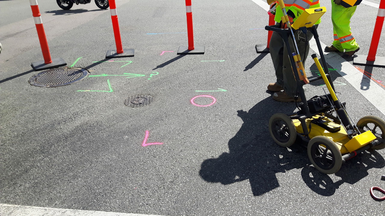
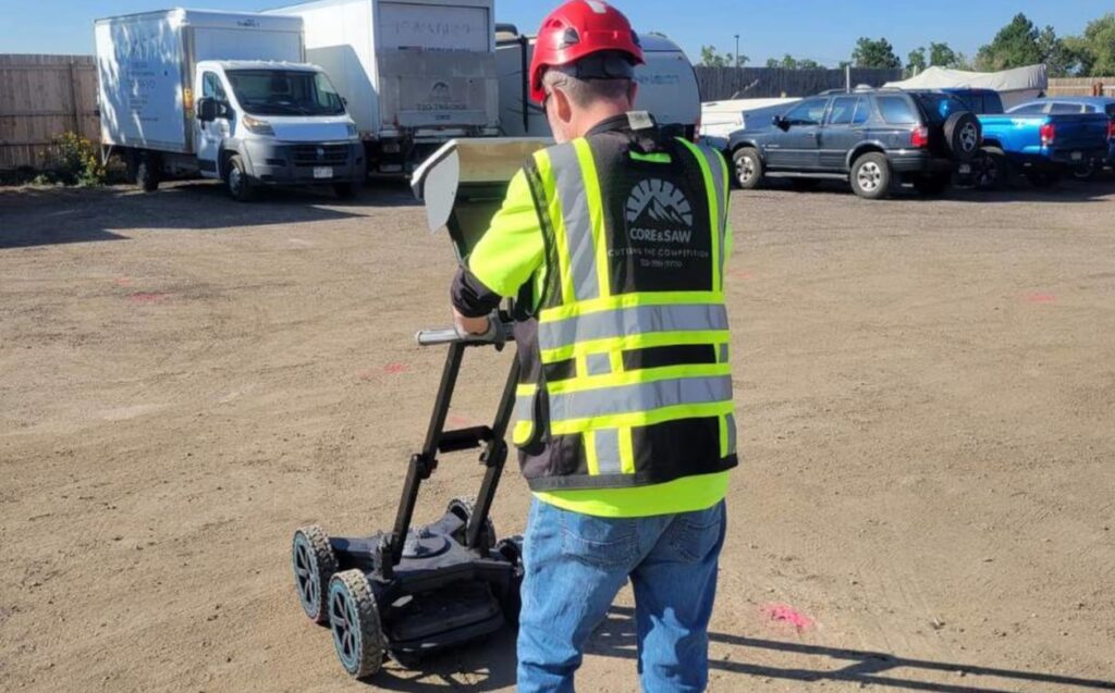
Advanced Detection Technologies
Modern utility mapping relies on sophisticated technologies to ensure accurate detection and documentation:
Ground Penetrating Radar (GPR)
- Uses electromagnetic waves to create subsurface images
- Detects both metallic and non-metallic utilities
- Provides depth information and spatial relationships
- Effective in various soil conditions
- Traces metallic utilities through electromagnetic signals
- Determines utility depth and orientation
- Identifies specific utility types
- Offers real-time tracking capabilities
Additional Survey Methods
To achieve maximum accuracy, utility mapping often combines multiple techniques:
- Radio Frequency Location: Traces active power cables and telecommunications lines
- Acoustic Detection: Identifies water pipes and assists in leak detection
- CCTV Inspection: Examines internal conditions of pipes and drains
- Vacuum Excavation: Provides visual confirmation of utility locations
The integration of these technologies with traditional surveying methods creates detailed utility maps that include:
- Precise geographical coordinates
- Depth measurements
- Utility specifications
- Material types
- Condition assessments
- Service connections
These comprehensive maps serve as crucial tools for construction planning, helping teams visualise the complex network of underground infrastructure before breaking ground.
The Importance of Utility Mapping in Construction Projects
Utility mapping is a crucial part of the planning process before construction begins. It helps project teams make informed decisions and manage risks effectively. By identifying and documenting underground utilities before starting any work, construction projects can follow a clear plan that ensures everything runs smoothly.
Key Planning Benefits:
- Accurate site assessment for project feasibility
- Precise cost estimation and budgeting
- Strategic excavation planning
- Efficient resource allocation
- Streamlined permit acquisition
Risks of Unknown or Inaccurately Mapped Utilities
Unknown or inaccurately mapped utilities can pose significant risks during construction work. These hazards can manifest in various forms:
Safety Risks:
- Electric shock from damaged power lines
- Gas leaks leading to explosions
- Water main ruptures causing flooding
- Structural instability from compromised utilities
Project Impact:
- Unplanned work stoppages
- Emergency repairs
- Legal complications
- Insurance claims
- Project delays
- Budget overruns
The absence of proper utility mapping can turn regular construction activities into high-risk operations. Even a single strike on an unmarked high-voltage cable or gas line can create immediate dangers for workers and nearby communities. These incidents often lead to a series of problems, including emergency service interventions and extensive property damage.

The Role of Utility Mapping in Mitigating Risks
Construction teams equipped with detailed utility maps can take proactive measures to ensure safety on-site. This includes implementing targeted safety protocols and making necessary adjustments to construction methods based on the information provided by the maps.
By having a clear understanding of where underground utilities are located, project managers can also develop alternative construction methods or modify designs when conflicts arise between utilities and planned work areas.
The Impact of Utility Mapping on Project Outcomes
Recent industry data shows that projects incorporating comprehensive utility mapping during planning phases experience 40% fewer utility-related incidents and maintain better adherence to projected timelines.
This highlights the importance of investing time and resources into proper utility mapping as part of the construction planning process. By doing so, project teams can significantly reduce risks, improve safety outcomes, and enhance overall project efficiency.
Enhancing Safety and Reducing Costs Through Accurate Utility Mapping
Accurate utility mapping delivers substantial benefits to construction projects through enhanced safety protocols and significant cost reductions. The implementation of precise mapping techniques creates multiple advantages:
Safety Improvements:
- Reduced risk of utility strikes during excavation
- Prevention of electrical hazards and potential electrocution
- Protection against gas line ruptures and explosions
- Safeguarding water main integrity to prevent flooding
- Enhanced worker confidence in excavation zones
Cost-Saving Benefits:
- Elimination of emergency repair expenses
- Reduced project delays and schedule disruptions
- Lower insurance premiums due to decreased risk
- Minimised compensation claims from utility damage
- Optimised resource allocation and equipment usage
Early identification of underground assets through utility mapping enables proactive conflict resolution. Project managers can adjust construction plans, redesign foundations, or modify excavation methods before breaking ground. This strategic approach prevents costly mid-project changes and keeps work flowing smoothly.
The financial impact of utility strikes can be substantial. A single incident might result in:
- Direct repair costs ranging from £2,000 to £100,000
- Project delays lasting days or weeks
- Legal expenses from damage claims
- Reputation damage affecting future contracts
Professional utility mapping services, such as those offered by registered surveyors, create detailed subsurface infrastructure documentation. This information becomes invaluable for current construction work and future site developments, establishing a reliable database of underground assets that supports long-term planning and maintenance.
The combination of advanced technology and experienced surveyors ensures precise utility detection, marking, and mapping. This systematic approach helps construction teams work confidently while maintaining strict safety standards and budget controls.
Case Studies: Real-World Applications of Utility Mapping in the Industry
Real-world applications demonstrate the practical value of utility mapping across diverse construction projects. Recent case studies highlight successful implementations in both telecommunications and government infrastructure sectors.
Telecommunications Sector Projects
- A major NBN infrastructure expansion required precise mapping of existing underground utilities across multiple urban areas
- The utility mapping process identified previously undocumented fibre optic cables, preventing potential service disruptions
- Telstra’s network upgrade projects benefited from detailed subsurface mapping, enabling strategic planning of new cable installations while protecting existing infrastructure
Government Infrastructure Initiatives
- School Infrastructure NSW (SINSW) implemented comprehensive utility mapping for educational facility expansions
- The mapping process revealed:
- Complex utility networks beneath proposed construction sites
- Critical water main locations requiring route modifications
- Historical infrastructure documentation gaps
- These findings allowed for proactive design adjustments, protecting both infrastructure and project timelines
The success of these projects demonstrates how utility mapping delivers practical benefits across different construction scenarios. The telecommunications sector projects showcase the importance of precise documentation for network expansions, while government infrastructure initiatives highlight the value of early utility detection for public works projects.
Choosing Competitively Priced Yet Reliable Utility Mapping Services
Selecting the right utility mapping service provider requires careful consideration of both cost-effectiveness and service quality. Professional surveying and locating companies structure their pricing models based on several key factors:
Project Scope Variables:
- Site size and complexity
- Required accuracy levels
- Time constraints
- Equipment requirements
- Data delivery format
Competitive service providers offer flexible pricing arrangements, including:
- Per-day rates for straightforward projects
- Project-specific packages for complex developments
- Volume-based discounts for ongoing partnerships
- Negotiable rates for long-term contracts
The most cost-effective utility mapping services demonstrate:
- Technical Expertise: Qualified professionals using advanced equipment
- Quality Assurance: Rigorous data verification processes
- Responsive Communication: Clear project updates and documentation
- Efficient Project Management: Streamlined workflows reducing unnecessary costs
A reliable provider balances competitive rates with service excellence through:
- Investment in modern technology and regular equipment calibration
- Continuous staff training and development
- Comprehensive insurance coverage
- Proven track record of successful projects
Price should not be the sole determining factor when choosing a utility mapping service. The potential costs of inaccurate surveys or delayed projects far outweigh any initial savings from choosing the lowest-priced option. Companies that maintain transparent pricing while delivering consistent, high-quality results represent the best value for construction projects.
In fact, as outlined in the Washington State Department of Transportation’s construction manual, the importance of precise utility mapping cannot be overstated in relation to overall project success.
Conclusion
Utility mapping is a crucial part of ensuring successful construction projects. By using comprehensive utility mapping services strategically, we can gain several important benefits:
- Improved Safety Measures: Accurate mapping helps prevent accidents and keeps workers safe from dangerous encounters with underground infrastructure.
- Reducing Risks: Having detailed information about underground utilities helps us avoid unexpected costs and minimise disruptions to the project.
- Efficient Project Management: Identifying utility locations early on allows us to plan better and execute tasks more smoothly.
- Controlling Costs: With precise mapping, we can avoid going over budget due to conflicts with utilities and the need for redesigns.
Investing in professional utility mapping services is invaluable when considering the potential costs of utility strikes, project delays, and safety incidents. Construction projects that prioritise thorough utility mapping consistently show improved completion timelines and adherence to budgets. This essential service goes beyond being just an initial expense; it becomes a vital tool for managing risks, protecting project success, and safeguarding the interests of stakeholders throughout the construction process.
Related : Surveying Engineering Services: What You Can Expect